| Day
22 (Aug. 2nd): ESTES PARK to GLENWOOD SPRINGS, CO |
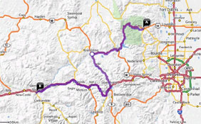 |
| <- PREVIOUS DAY | Predicted Dist. & Time: 215 mi. / 4:30 - Actual Dist. / Drive Time / Total Time: 198.7 mi. / 4:32 / 6:01 | NEXT DAY -> | |
|
Click n' Return:
|
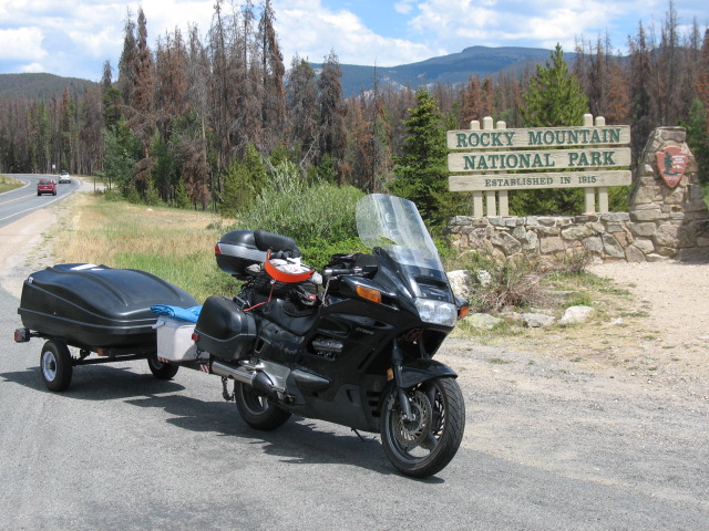
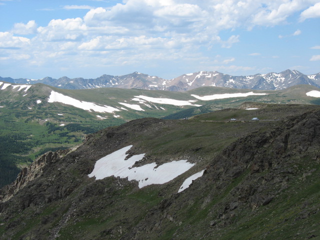
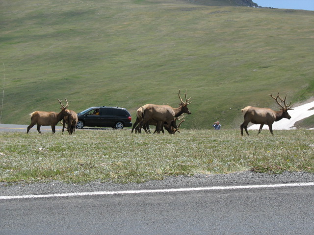
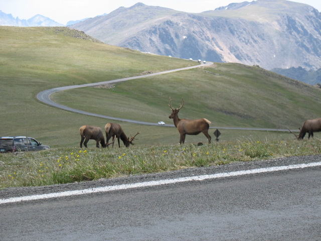
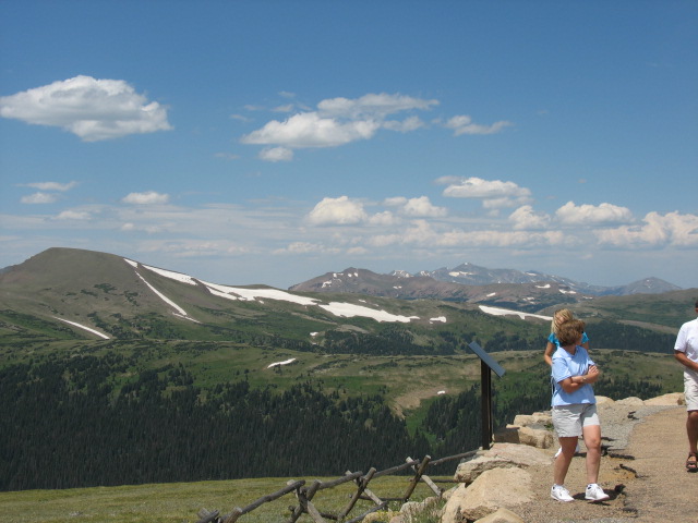
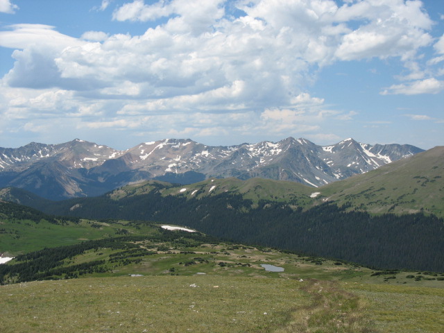
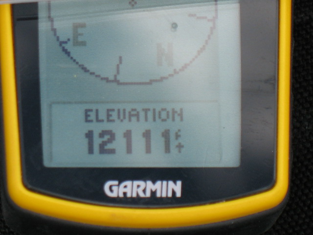
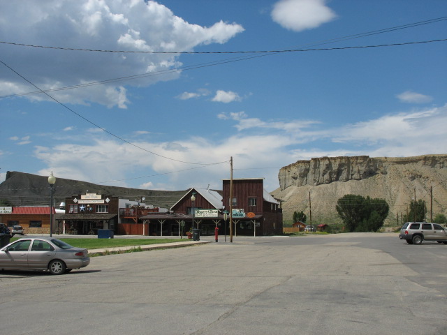
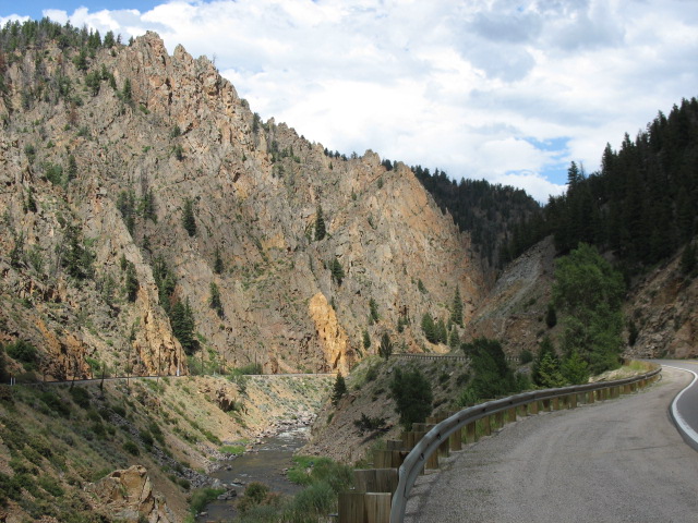
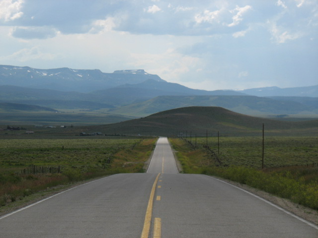
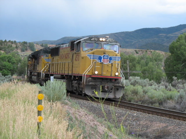
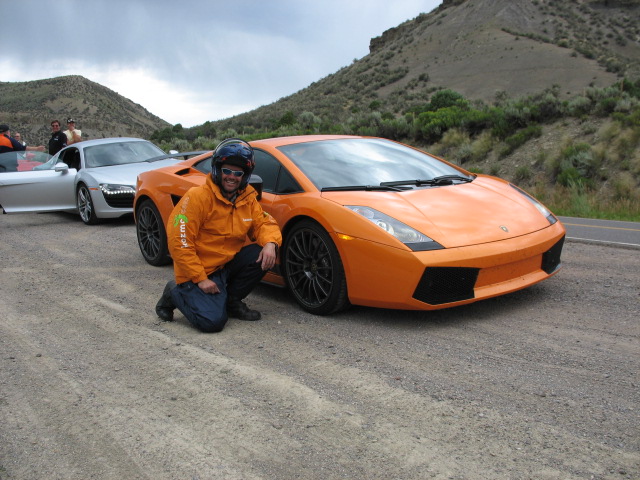
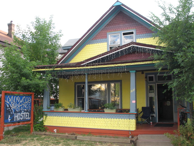
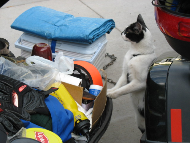
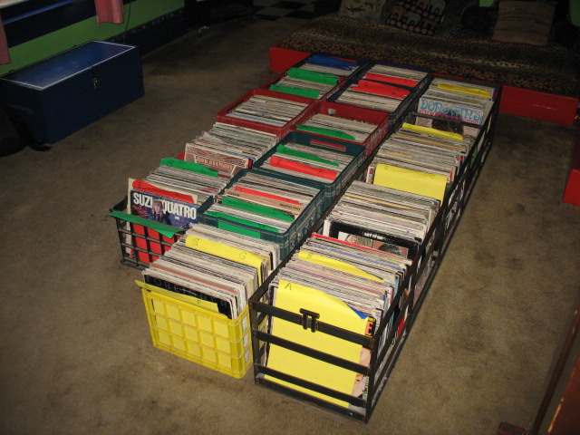
DAY TWENTY-TWO COMMENTARY Despite having been out late the night before, I awoke fairly early as the sun brightened my sleeping area out on the lanai. I was poised to hit the road in reasonably quick fashion, having taken very little out of the trailer the day before, but then I spent quite a bit of time chatting with the family reunion gang. We talked about my trip thus far, discussed sightseeing recommendations that the locals knew of, checked out this very website on somebody’s laptop, and so on. It was a worthwhile gab session, and in the end I was still on my way well before noon. Now, recall I had said that gas cost $4.29 or something ridiculous here in town, and there was no way I wanted to pay that. Thing is, it was going to be a very close call as to whether the amount of gas I had left -- yes, including the two gallons in the spare can -- would be enough to get me to my next stop, Glenwood Springs. Especially considering that the bike would probably be working overtime to get the rig up and over the peaks inside of Rocky Mountain National Park, and that actual distances on the trip seemed to be longer than what the map websites had been predicting. The locals said that prices would remain high in the next two towns, Grand Lake and Hot Sulfur Springs, but level off after that. OK, I knew I could make it about 200 miles on what I had, and I’d definitely hit something else along the way, so The Great Gas Gamble was on! Bought ice for the day a mile down the road from the National Park entrance. Approaching, I was a little bummed that the entrance fee looked to be $20, but then it turned out to be only $10 for motorcycles! The road through the park was the real deal, climbing to some 12,000 feet in elevation, and sometimes closed due to residual snow well into the month of June. There was certainly enough snow up on some of the peaks even now. The rig seemed to be progressing up into the skies with little undue fanfare, despite the fact that its carbureted engine couldn't adjust its intake ratio to compensate for the thinner air at these altitudes, as could a fuel-injected mill. Sure, I had to downshift it here and there when momentum slowed, or before blowing by people who would slow down -- but somehow not actually pull over -- at the scenic views, but it was nothing like the disaster scenarios that many well-meaning observers had forecast. The elevation on my handheld GPS kept rising, and the road was steep and twisty, but below the timberline (~11,000 ft.?) the trees served to minimize the visual impact of the drop-off just a foot or two past the edge of the road. When we climbed above the timberline, the severity of the drop became far more noticeable because there was nothing to hide it from view. Suddenly, the prospect of catching the sights while under way turned rather more frightening, as the consequence of an off-road misstep was now plain to see -- and it was a long way down. Up at around 12,000 feet, while both rider and bike may become partly short of breath, one element that the bike likely does not share is complete and utter terror on what I’ll refer to as ‘the catwalk’. I had remembered this section from my brief ride on the road during a past visit, but it hadn’t yet come to mind today while I was riding. I imagine that the road curls between two mountaintops, or something like that, because for about a 100-yard length the extreme drop-off looms on both sides of the pavement. One moment you’re sneaking looks at the mountains in the distance to the left -- mainly to avoid looking at certain death two feet away to your right -- when suddenly there’s nothing beyond the edge on that side either, and you realize that the margin for error here is limited to the width of the two-lane road. Sure, there’s no reason why the topography itself should make one deviate from a direct line, but the impression of imminent disaster is horrifying; I know for a fact I was staring straight ahead and squeezing those handlebars to within an inch of their lives. Even more danger lay ahead, this time due to human stupidity. Perhaps a mile further on, near a hairpin turn with a noticeable change in grade, there was a herd of elk grazing right at the edge of the road. Naturally, this attracted the attention of motorists, some of whom pulled over to take pictures, and one of whom -- the idiot/sole occupant of a giant Cadillac SUV directly in front of me -- decided to stop right there on the road in the middle of the turn. That forced me to come to a quick stop, on an uphill curve, at a spot offering me little in the way of balance as the left side of the road was far lower than the right. Now I was really ticked off, because if I were to tip over here, it would be even worse than on level ground (not to mention that it was in the middle of the road). So when the driver’s window eased down I let loose with a barrage of, um, criticism that caught the attention of not only the driver, but also the folks who had done the right thing and pulled over. Before the guy could even try to explain that it was a scenic opportunity -- with which I could certainly not argue -- I told him he was endangering me and the people behind me and that he’d better move that POS or I was going to move it for him. He certainly got the heck out of there, and I pulled over to snap a few more pix myself, but even that wasn’t easy because the side of the road remained at a severe diagonal slope as well. Further ahead there was a pullout which I believe was called Forest Overlook, providing an expansive view of the mountains in the distance and of the valley floor below. Whipping out the binoculars, I could see that the otherwise invisible beige dots some two miles down were actually about 15-20 more elk, doing their thing far removed from the presence of people. Here I saw a newer version of the VW Bus with license plates from Germany. At Milner’s Pass the road technically crossed the continental divide, and we started to descend down towards the town of Grand Lake. Exiting the park territory, along a subsequent five or ten-mile stretch there were two or three interconnected lakes offering all sorts of water-related recreation, with the park's ten thousand foot peaks as the backdrop. As predicted by my people on the ground back in Estes Park, the gas prices here remained high, but at a crossroads further on it dipped down to $3.999, so I concluded that I’d be in good shape as the ride progressed. I passed through the small town of Kremmling; through a neat little chasm called Byers Canyon; and saw evidence of Pine Beetle devastation near Gore Pass, which looks rather like the turning of the leaves in the fall, and is arguably scenic, except that these are pine trees which do not otherwise change colors and instead are either dying or already dead. These huge swaths of affected trees, out amongst healthy ones, increase the danger of the rapid spread of fire. On a brighter note, Rtes. 134 and 131 offered fantastic, varied scenery, a train coming through a tunnel, and a series of high-end sports cars (cheapest model: the $110,000 Audi A12) on a demo run. I finally had to turn west onto the Interstate at the town of Eagle, but I was soon to learn that this was no typical superslab; the thirteen-mile long I-70 Corridor through Glenwood Canyon was hailed as both an engineering accomplishment and a commitment to preserve the natural beauty of the area. The road curved its way between the sheer cliffs looming hundreds of feet high above, along the path cut by the river below, sometimes running atop the eastbound lanes in a type of shelf arrangement, sometimes tunneling through the rock walls. Even in the dim light of this cloudy early evening, the visual impact of the corridor was undeniable. I would have pulled over to take pictures, but by now -- having pushed the Great Gas Gambit to its ultimate limit -- I figured I had, oh, y'know, an ounce or two of fuel left at most, with the spare can already having been used (good thinking -- Ed.) Keeping an eye on the traffic, and the scenery, and the GPS and odometer as they counted down the distance to my exit, I kept thinking, “OK, the further I can coast, the less I have to walk to fill up the spare can…as long as there’s a place to pull over!” What was I rewarded with when I did, in fact, manage to make it to the Shell station at the exit? This. So despite having been way ahead on my estimate of my possible riding range, like the obstinate dope that I can occasionally be I blew it by not paying $3.999 way back when! Final score: The Great Gas Gambit 1, The Chief (tm) 0! Passing through the cute little downtown area, I was thrilled to see that I had made the right call on the Glenwood Springs Hostel at which I would stay for the night. Not only was it just a few blocks from all the action, but the managers Clarisa and John, the layout of the place, the friendly cat and kitten in the lobby, and the hundreds of record albums in the foyer all had me thinking: do I call another audible here? I felt like I wanted a break from the pack/unpack/travel routine. They already knew I couldn’t stay in the same private room for the second night, but the bunk I could have in the "dorm-style" room would only cost like $12 or $16 or something similarly ridiculous. I made the decision on the spot: I was staying for a second night! After freshening up, I ambled down to the Doc Holliday Saloon, where I met super-nice folks (all weekending up here from Denver) such as Dave and Carrie (please excuse the possible misspelling!), and Mark (please excuse the possible misspelling!) and Jane. Dave, originally from Alaska, assured me that Carrie would soon be dancing up on the bar, “Coyote Ugly”-style, and despite much imbibing of adult beverages, cooler heads prevailed and no such event took place (darn -- Ed.). Mark and Jane had completed a hike up to Hanging Lake earlier in the day, back east a few miles through the I-70 corridor, and strongly recommended that I do it while I was in the ‘hood. Seeing as how I wished to take some photographs of that area anyway, the combination was a clincher for me, and I decided that this was what I would do with my day tomorrow. (Somewhere along the line we also chatted about snowboarding, during which conversation I learned that the term to describe the order in which one places one’s feet on the board is “’regular’ or ‘goofy’”. How would I otherwise have ever heard about that?) Later on I spoke to John, from Maine, who was in the area for training and had rented a motorcycle to help take in the beautiful scenery. Naturally we discussed some of the routes that I had recently enjoyed, then went down the street in search of more drink, ending up at a pretty happening dance club for a few hours. (Yes, I may have blown it by not going directly to the bar right next door, tended by a cute girl I briefly chatted up in Doc Holliday’s, but what can I do about that now?) I don’t know what time I got back to the hostel, but I do remember at some point waking up fully clothed on the bed and wishing to use the restroom, both of which were somehow occupied at 4:15 AM. I also somehow found myself with two bottles of Advil, not just the one I remembered having purchased earlier in the trip. Listen, people, after a night like this, I was gonna need fast, effective pain relief! |
|
|
|
|
|||